The weather forecast wasn’t looking good, thunder and rain was forecast. Perhaps we wouldn’t get to do the Drei Schwestern, the main bit of the ridge.


Inspiring Your Outdoor Adventures
The weather forecast wasn’t looking good, thunder and rain was forecast. Perhaps we wouldn’t get to do the Drei Schwestern, the main bit of the ridge.

Having been involved in the local LEADER funding panel which approved the funding for the Stanza Stones project, and living in Marsden, I’ve been meaning to complete the 50 mile route linking the stones together for a long time.
As it was created over 10 years ago, it felt like a good time since I was looking for a long challenge for the summer.


This year I wanted to complete some local long distance routes as part of training for my next big race. Having never really explore Cheshire despite it being so close to home, The Gritstone Trail was an obvious contender.
The trail guide recommends walking North to South but I wanted to finish closer to home so logistically it would be easier. So on what turned out to be a scorching hot day during a rather cold and wet British summer I set off from Kidsgrove.


Having wanted to hike in the Pyrenees it seemed a good opportunity to visit Andorra – a tiny country tucked in between Spain and France entirely in the mountains. I knew Andorra was a good ski destination but was intrigued to find out about summer hiking there.
Having looked at the various long distance trails in the mountains I stumbled across the Coronallacs, a new circular route utilising various existing long distance paths through the mountains.
The Coronallacs is a 92km route which we chose to do in 5 days, allowing us to stay at the 4 manned huts in the mountains. This allowed us to carry less as the huts provide dinner and breakfast as part of the fee.
Continue reading “Hiking the Coronallacs”
I had entered the Dragons Back Race in 2022 as a 40th birthday present to myself but then quickly bottled out – feeling under prepared and like I was trying to achieve the impossible. Having deferred a year I was then committed to doing it in 2023. This ‘do it now or lose my money’ committed me to training properly and gaining the confidence in myself too.
The Dragon’s Back Race is a 380km mountain race which covers over 17,400m of ascent over the 6 days. Yes that really is twice the height of Everest for those of you that wonder if I stuck in too many zeros. It heads from Conwy Castle in North Wales to Cardiff Castle in the South, twisting and turning as it crosses most of the major mountain ranges in Wales.
Continue reading “Being the Ultimate Dragon – Dragon’s Back Race”
Sweating pouring down my back, muttering expletives under my breath as I carried my On-One 456 on my shoulder. Seat digging in and the pedals constantly clipping my leg. As I emerged from the woods I put my bike down to find 4 ticks on my legs. That was it. I lost it.
Mountain bike the West Highland Way?! Who’s stupid idea was this?
Continue reading “Mountain Biking the West Highland Way”
The Kirklees Way circles the borough providing a 73 mile/ 118km challenge which takes in some of the areas rugged trails and industrial scenery, along with plenty of farmland, moorland and woodlands.
I undertook this route over three days, but 4-6 days is more realistic.
I should add that like many named routes in the area, the Kirklees Way might be a marked trail on the map, but a lot of the route isn’t well signposted and can be quite overgrown (especially at the height of summer). Some of the stiles and gates are also in poor condition. Map reading is definitely required!
Continue reading “Tackling the Kirklees Way”
Stuck at home during the Covid-19 Lockdown I decided there had to be challenges I’d not done before right on my doorstep. Staring at an OS map it occurred to me my home in Marsden was surrounded by Trig points at some pretty good locations – and so the 6 Trigs circular was born!
The 6 Trigs Circular – 39 km /24 miles

Starting in Marsden village, the joy of this route is that it is possible to do as much or as little of it as you like. The route circles the Marsden area on mostly well marked trails with some good alternative paths to shorten the route.
Continue reading “The 6 Trigs Circular”
I first walked the Colne Valley Circular when I moved to Kirklees 11 years ago. All I recall of that time was the mud, failing to find the route properly above Slaithwaite and more mud.
Trapped at home over Easter I decided to run the route one afternoon and figure out if it really was as bad as I remembered.
The Route
Firstly, if you’re keen to walk (or indeed run) the Colne Valley Way you absolutely must have a map. This is a route which is NOT well signposted and at various points it actually feels like you’re being prevented from progress. Persevere though, as the route has some hidden treasures along the way.
Continue reading “Tackling the Colne Valley Circular”
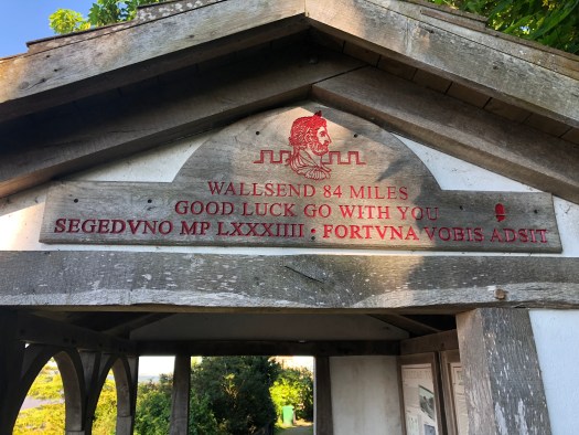
Firstly, I’m not an ultra runner and have only run a marathon distance once. So it was with this knowledge that I cautiously planned to run Hadrian’s Wall Long Distance Path. I set myself the challenge to complete the route over 4 days (and one evening) and while that is easy for walking, I wanted to be able to run as much of the route as possible which would make it a challenge.
If you’re going to complete this route I recommend West to East as the wind will be behind you encouraging you on. For some reason more people seemed to walk it the other way. Its definitely possible to de entirely on public transport, as Carlisle and Newcastle are on main line stations, with good buses and metro service at either end to get you to the start/finish.
Finally, get yourself the Hadrian’s Wall Passport from either the Fort in Newcastle or Carlisle Tourist information, so you can collect your route stamps along the way. Its a nice memento of your journey!