

Firstly, I’m not an ultra runner and have only run a marathon distance once. So it was with this knowledge that I cautiously planned to run Hadrian’s Wall Long Distance Path. I set myself the challenge to complete the route over 4 days (and one evening) and while that is easy for walking, I wanted to be able to run as much of the route as possible which would make it a challenge.
If you’re going to complete this route I recommend West to East as the wind will be behind you encouraging you on. For some reason more people seemed to walk it the other way. Its definitely possible to de entirely on public transport, as Carlisle and Newcastle are on main line stations, with good buses and metro service at either end to get you to the start/finish.
Finally, get yourself the Hadrian’s Wall Passport from either the Fort in Newcastle or Carlisle Tourist information, so you can collect your route stamps along the way. Its a nice memento of your journey!
Bowness on Solway to Carlisle – 15 miles
Having caught the train to Carlisle I dropped some stuff off at my hotel for the night and caught the bus to Bowness on Solway for an evening run of this part of the route. I had toyed with the idea of not bothering with this bit and doing Carlisle to Newcastle only, but the completer in me had to do the whole thing. The bus was £6.90 and was only 40 minutes, I had no excuse really. It was even sunny!

To be honest though, anyone who decides to start or finish at Carlisle still acceptably completes the route in my opinion. On getting off the bus in Bowness I trotted happily along the coastal path before the route winds on farm tracks into Glasson and then Drumburgh before hitting the long section of road all the way into Burgh by Sands. This would have been a dull section to walk but wasn’t much joy having to run.


From here there is another farm track into Beaumont before I discovered the disappointment of a path diversion resulting in more road. It was a beautiful sunny evening though so I tried not to complain.
Eventually I was able to pick up the path at Kirkandrew-on-Eden to reach the river and a lovely track into Carlisle. With all that road running my left leg was already starting to be unhappy as I reached Carlisle quite hungry. Despite the whinging to myself it was a beautiful evening of running in the sunshine.
Carlisle to Greenhead – 20 miles
I set off optimistic about the route today. I was finally going to see sections of Hadrian’s Wall and pass through open countryside. However, I’d barely left Carlisle before my knee started to scream so the pace was slow and tedious all day, though I ran as much as possible. The expectation of being able to run most of the route and actually having to stop and stretch every 4km, I felt disappointed and beaten.

The route heads out of Carlisle by following the river and country lanes towards the M6 and beyond. Upon reaching Crosby on Eden it heads briefly North to reach the remains of the Wall. Passing by the Wall’s Milecastles and following it’s ditch, the route starts to become hilly as it reaches the village of Oldwall and Newtown.


The miles of fields were a joy to run through and for every village the route passes through there is a house selling drinks and snacks or honesty boxes of snacks. I couldn’t resist the honesty fridges selling lollies!

The long slog uphill to Hare Hill felt hard work in the heat and with a sore knee, but the top marked a change to run on the flat for a while. I had a quick break at Birdoswald Roman Fort in order to collect my Hadrian’s Wall passport stamp before heading downhill to the river.
Marked on the map as a Roman bridge there is actually a large metal bridge over the river now but it’s still worth a visit for the impressive foundations of the former Roman bridge and the long section of wall.

From here it was a few miles more through Gilsland and into Greenhead where I finished running for the day. Of course I had booked accommodation slightly off the route and so had to stroll down to Blenkinsopp Castle for the night. Despite complaining to myself for not booking somewhere on the route, it turned out to be well worth the extra distance it as it was a lovely spot. A gorgeous pub with friendly hosts and a lovely room with my own patio! It felt like luxury on a sunny evening!
Greenhead to Chollerford – 17 miles
I woke stiff and feeling like the day was going to be a tough challenge. Having spoke to my partner that morning for moral support, he pointed out that I was running almost back to back marathons so I was bound to be tired and sore. Ok, I wasn’t doing marathon distances but it did make me realise that what I was doing was a challenge for someone who’d never done back to back long runs before.
I started the day with a trudge up the hill to get back onto the route at Greenhead. The running felt comfortable for a while and the views were amazing. This section of the route is pretty hilly as Hadrian’s Wall and the Long Distance Path follow the Great Whin Sill fault line. This long layer of dolerite rock surfaces in this area, forming a long crag and creating a natural boundary that made building Hadrian’s Wall here logical. (The Geological Society have a really interesting page about the Great Whin Sill – follow this link). At least the uphills gave me an excuse to slow down and walk for a short section.
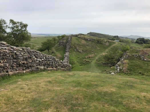


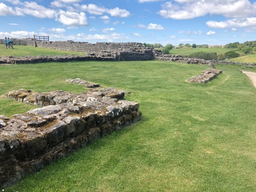
This has to be my favourite section of the route, much of it I have walked before when completing the Pennine Way over 5 years ago. Passing turrets, Milecastles and old Roman Forts the route occasionally breaks for small country lanes before heading uphill again to wide views and more milecastles. The best views are from above Highshield and Hotbank crags.


I stopped briefly for a drink and to get my stamp at Housesteads Roman Fort, one of the biggest forts along the Wall. From here the was one more hill and Trig point before heading downhill towards the road. Here I met the Long Distance Walkers Association Hadrian Hundred participants. A string of walkers heading towards me, with the expected jokes that I was heading the wrong way, the stalwarts with their heads down marching and not expecting to see anyone walking towards them and endless smiling faces happy to say hi. I was pleased when I met the last of them at Brocolitia Roman Fort and the little temple of Mithras.

Here the weather also turned and the end of the day was marked by cloudy skies and cold winds. The remains of the Wall also start to become less visible and marked more by ditches in the landscape. So it was a pleasure to reach Chesters Roman Fort and finish for the day.
I stayed in Acomb at the Queen’s Arms Hotel which was a hidden delight in this quite little village.
Chollerford to Newburn Bridge – 17 miles
I woke to rain and the prospect of standing around waiting for a bus to take me back up to Chollerford. Thankfully by the time I disembarked from the bus it had stopped raining heavily and turned to drizzle.
This section of the route hadn’t inspire me when I looked at the map and saw that for most of the way the path followed the road. I had expected it to be just the other side of a fence in a field and fairly uninteresting. I was really surprised to find it winds through small woodlands, and fields bounded by amazing hawthorn hedges and wild flowers. However, this section does have the highest quantity of stiles, in some place 5 within 50 metres!


Reaching Whittle Dene reservoirs felt like a significant marker as the Path continues on a from here to the A69 and eventually heads South to Heddon-on-the-Wall and the River Tyne.


Of course I’d chosen not to stay on the route but the other side of the river near Ryton, in what turned out to be the quirkiest B&B I’ve ever stayed in. If you’re ever in the area and want to stay somewhere reasonably priced with a four post bed, slip bath and a hall of buddhas, armour and Chinese cats then Hedgefield House is the place for you. It was a lovely place for my last night.
Newburn Bridge to Wallsend – 11 miles
This section of the route is entirely on tarmac as it follows a cycle track and winds through housing and along roads. As a walk it could be a bit dull as Hadrian’s Wall itself has disappeared but it makes a nice run into Newcastle. Eventually it meets the River Tyne again and leads you into the City itself. Running in the rain with a very sore leg I was definitely pleased to see the Tyne Bridges and feel like I was making progress.


As the route leaves the city centre of Newcastle it continues to follow the River, though in places its not well sign posted and I did find myself running through an industrial estate before I eventually found the path again. Its quite unremarkable as much of this area is industrial, being once the site of Tar Works which have left its mark on the river’s water quality, and now being the site of large international oil and gas and steel companies part of the Port of Tyne.
Hadrian’s Wall itself takes a direct line through the City of Newcastle but I think the choice to make the Long Distance Path follow the River Tyne is a good one. The route at this point might be lacking in history but the Tyne does have woodland along its edge and is much prettier than walking through housing.
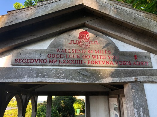
Reaching Wallsend felt amazing. The Fort has a fantastic museum and cafe so if you’re finishing your journey here its worth a stop and a look around before you jump on the Metro back into the City – and of course get your last stamp in your passport. It was lovely that the staff were excited to hear about how I’d got on and what I thought of the route.
I would definitely recommend the Hadrian’s Wall Path, either as a running adventure or even as a first long distance path adventure. It is easy to break down into manageable distances with lots of places to stay along the route. It’s also super easy to do by public transport, which can’t be said for all long distance paths.


Great read – as we’re thinking of doing this also by breaking the run down over 4 days.
How did you transport your luggage?
I used https://www.sherpavan.com They were fantastic – I just told them where I was staying each night and they organised moving by bag for me. On the final day it got left at the museum at walls end.