Hiking Monte Inici

Having managed to escape the UK for only a week this year and finding ourselves in Sicily for sport climbing and sunshine, I was surprised that there wasn’t more information on hiking in the mountains given that Sicily is quite mountainous. In fact the only map I could find was of the Etna region.

Spending a few days in Castellamare del Golfo we were making the most of the beaches and the sport climbing in nearby San Vito. Castellamare del Golfo is busy little fishing town which has a typical touristy beach and restaurants. Its is also overshadowed by Mont Inici.

Despite the dominance of the mountain on the town it seemed few people walked up there, with no maps available and very unloved footpaths and trails. There were however intermittent signposts at junctions making it possible to see that once it had been a popular area to hike.

So, armed with digital mapping (which turned out to be pretty accurate on all our walks in Sicily) we set off on the tracks from the view point above the town.

Continue reading “Hiking Monte Inici”

Walking in Asturias – The Camino Real del Puerto de la Mesa

Having hiked in Asturias a few times before I was prepared for open trails and amazing views. The Camino Real del Puerto de la Mesa, high up in the mountains provides all this, along with an amazing insight into local history.

The GR-101 is a path that runs from south to north through Asturias, leaving Torrestío and ending at Las Cruces, after passing through Belmonte. The route follows the old Roman road of La Mesa, more commonly known as El Camín Real. This route linked the Castilian plateau with the town of Gijón.

The Roman road is around 45km long. This trail also has a variant, the GR-101.1 Camino Real de Cueiru to Villanueva, which is what we walked (in reverse).

For an Open Street Map view of the whole of the GR101.1 click here – we opted to walk as far as the old historical town of Bandujo / Banduxu.

Continue reading “Walking in Asturias – The Camino Real del Puerto de la Mesa”

GetOutside and explore the Dales Way

Sometimes in life the best adventures are those you don’t choose for yourself. The Dales Way doesn’t involve bog trotting or peak bagging, but instead winds through picturesque valleys and villages following the rivers. It was a beautiful weekend; full of wildflower meadows, sheep and sunshine. Except for the day we got thoroughly soaked in a thunderstorm, but more about that later.

The suggestion for Sharon and I to do a long distance walk together was first uttered over beers at Christmas (were we drunk?) and despite the potential for it to be forgotten about after the hangovers had vanished we committed to completing the Dales Way – a route which could be done over a long weekend.

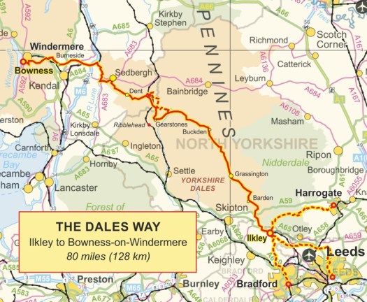
Covering 80-ish miles (that’s the official length!) the Dales Way passes through villages as it follows rivers from Ilkley to Windermere.

route.jpg
From Dalesway.org
Continue reading “GetOutside and explore the Dales Way”

Via ferratas and a difference of opinion about the grades

Since the weather had become cloudy and threatened rain we couldn’t head back up on to the snow so a few of us headed down the valley to Passy to do the Via Ferrata called Curalla.

Graded in our Cicerone guide as VF2B and on UKclimbing as VF1B I was very confident about being able to manage this. I’d done harder grades in the Dolomites last year – or so I thought. However it seems the French have a different opinion about grades.

The route starts just outside Passy village and involves a 20 minute walk through the woodland to reach the crag.

DSC01315
Continue reading “Via ferratas and a difference of opinion about the grades”

Dealing with injury and getting active again

Sorry for the lack of posts for the last month. I’ve done nothing worthy of writing about. By that I mean I haven’t walked more than a mile in a day – its been mind numbingly boring and cabin-fever frustrating.

After a fantastic trail run at the Keswick Mountain Festival and then completing the Dovestones Diamond 10k in the rain a week later I felt fantastic and totally ready for running a half marathon. Nevermind the summer months rock climbing and peak-bagging over the fells.

IMG_7704
Continue reading “Dealing with injury and getting active again”

Dolomites- Stepping up a grade on the Col dei Bos

Having survived my first Via Ferrata a couple of days previous but all of us keen to avoid having the mega long walk in we’d had on the Sorapiss, we decided to pick a route which had a short walk in for our next route.

The Col dei Bos route is east out of Cortina on the Falzarego pass and has only a 20 minute walk in from the road. It is grade 3b making it trickier than the previous route we’d done. Before we reached the rock face however, we arrived at the old Italian military hospital, our first indication on our trip that this whole area was on the front line of the Italian and Austrian battles in the First World War. The whole area is an impressive memorial to its history and its amazing how much is still standing.

DSCF8084
Continue reading “Dolomites- Stepping up a grade on the Col dei Bos”

Bivvying on the Sorapiss Circuit

Parking at Tre Croci just outside of Cortina, we set out with the intention of doing the Sorapiss circuit over two days, completing the three via ferratas en route and bivvying at one of the remote bivouacs half way.  This did however require us to carry all our own water as the last available water source was Rifugio Vandelli 2 hours walk in from the road.

Despite leaving before 9am it was already scorching hot as we walking through the scrub and woodland on the way to the Rifugio. The route (and heat) reminded me of walking on the final few days of the GR20 and there was more than a bit of relief from us all when we arrived at the Rifugio and were able to top up our water bottles for the rest of the hike – being pleasantly surprised to find this was also free.

DSCF8043

Continue reading “Bivvying on the Sorapiss Circuit”

Sunshine on the Ben Lawers Round

The sun was shining, the midges were sleeping and the cloud across the Ben Lawers summit was looking like it would lift. What a perfect day for climbing mountains, it was hard to believe I was in Scotland.

Intending to do all of the 5 munros on the Ben Lawers range I knew it was going to be a long walk with a really dull slog back to the car. As I parked up at 9am at the main car park I was surprised by the number of cars already there and also by the information about the Nature Reserve on the large stones. Enough to distract me from my hike. From the car park the route starts sedately through the Nature Reserve.

image
Continue reading “Sunshine on the Ben Lawers Round”

Bog trotting – munro bagging

I’m not sure I fit the stereotype of the typical Munro bagging, surely they have old 1980s oversized waterproofs in neon colours, big heavy gaiters over old boots, rucksacks you could fit yourself in and doggy determination to walk for miles and miles.

As I stood ankle-deep in the peat bog between Meall Glas and Sgiath Chuil I had to question whether I was, however, crazy. To start with neither of these mountains are significant players in the munro lists (199 and 270 highest out of 283), there is no distinct path across the endless bog between the two and frankly there are nicer munros in the Trossachs – I’d even bagged 2 the day before.

But I was there and even when the sun turned to rain there was no point turning back. I think that statement either marks me as a munro-bagger or just plain mad.

The hike starts out from the A85 in Glen Dochart, parking at Auchessen – a lovely little spot on a surprisingly sunny day.

image
Continue reading “Bog trotting – munro bagging”